Activities / Hiking
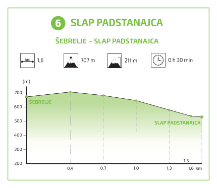
Šebrelje – Padstanajca (1,6 km; 30 min)
The most prominent waterfall on the Sjavnca stream is the lower waterfall, which was interesting to archaeologists during archaeological excavations in Divje Babe. During the Second World War, a communist party school was in its immediate vicinity. The school was discovered by the German army, which burnt down the set up barracks, as well as the village of Šebrelje, as a form of punishment. The waterfall runs like a ‘horse’s tail’ over a 28 m high overhang, below which there is a small cave. The waterfall is little known to hikers, but much more famous among ice climbers, as the stream freezes in the winter and the rock becomes an ice climbing spot. The Šebrelje-born alpinist, Slavko Svetičič–Slavc, used to spend a lot of his time on this wall. In the upper part of the waterfall, the stream runs through a narrow groove, and falls as a ‘horse’s tail’ on a rock where it is dispersed into a ‘fan’. The overhang makes it possible to walk behind the waterfall. Below the waterfall, there are beautiful rockfalls, similar to boulders.
From the Cerkno – Most na Soči road, turn left across the bridge over the Idrijca in the area of Stopnik. After some 4 km, the serpentine asphalt road will lead you to Šebrelj.
From here, turn right at the signpost at the crossroads, uphill past the fire house. After 300 metres of asphalt road, turn left at the board onto the macadam road leading downwards.
After 200 metres, at the board, turn left again, downwards into the forest. On the way, you can rest on the bench and enjoy the scenic views of Kojca, Porezen, Matajurski vrh, Raskovec, etc.
Continue steeply downwards on the path fortified with steps. You will reach the Padstanajca waterfall after 10 minutes, and can enjoy a walk behind the waterfall without getting wet. From here, you can continue your path to the National Liberation monument, but need to cross the Sjavnca stream to get there.
Attractions
The waterfall runs like a ‘horse’s tail’ over a 28 m high overhang, below which there is a small cave.
Hiking trail 6
Trail (on interactive map – blue): Šebrelje – Waterfall Padstanajca
Time: 0,5 hour
Lenght: 1,7 km
The lowest point of altitude: 530 m
The highest point of altitude: 707 m
GPX coordinates can be downloaded HERE.
*Download instructions: “right click” on the link, then select “save link as”. The appropriate application is required to open the file (for example: www.gpxsee.org).
Hiking trails in the Cerkno region
- Hiking trail 1: The Franja Partisan Hospital
- Hiking trail 3: The Forest Garden
- Hiking trail 4: Reka
- Hiking trail 4a: Mule track
- Hiking trail 5a: Želin – Ravne
- Hiking trail 6: Padstanajca Waterfall


